You are using an out of date browser. It may not display this or other websites correctly.
You should upgrade or use an alternative browser.
You should upgrade or use an alternative browser.
the climate crisis...
- Thread starter JayQQ97
- Start date
Rock62
Well-Known Member
The storm you have now rolled thru here last Wednesday night. It left 3.3 inches of heavy wet stuff. During the last few days, it has all melted off. Monday night we are expecting storm #2 in this series. Then when that clears, the bottom will fall out of the thermometer coupled with windchill.
I'm ready for Spring.
I'm ready for Spring.
Rock62
Well-Known Member
Its still undetermined what form we'll get. I expect a mix of rain, freezing rain, snow, wind. In other words...ICE & WIND.
Fortunately, the company I work for allows working from home in these situations. They even gave me a nice stipend to set up my workstation at home with a monthly kick supporting internet service. No reason to risk driving on dodgy roads.
Fortunately, the company I work for allows working from home in these situations. They even gave me a nice stipend to set up my workstation at home with a monthly kick supporting internet service.
JDubTaco
Well-Known Member
No thanks! I hate it when it's in the 40's, I cant imagine -18!a light snow fell last evening here, more like a trace amount
expected 2" to 7" on Monday but probably mostly rain mixed into snow
OMG! then they forecast more snow later in the next week
and then temperatures plunge to possibly 50 degrees below freezingnext weekend
that is -18*F approximately
bitter cold for a few days
JayQQ97
MW surVivor ... clutched. 369k on the 0D0
the wind from the north makes it so MUCH worseNo thanks! I hate it when it's in the 40's, I cant imagine -18!
its been revised up to just -12*F for the lows
JayQQ97
MW surVivor ... clutched. 369k on the 0D0

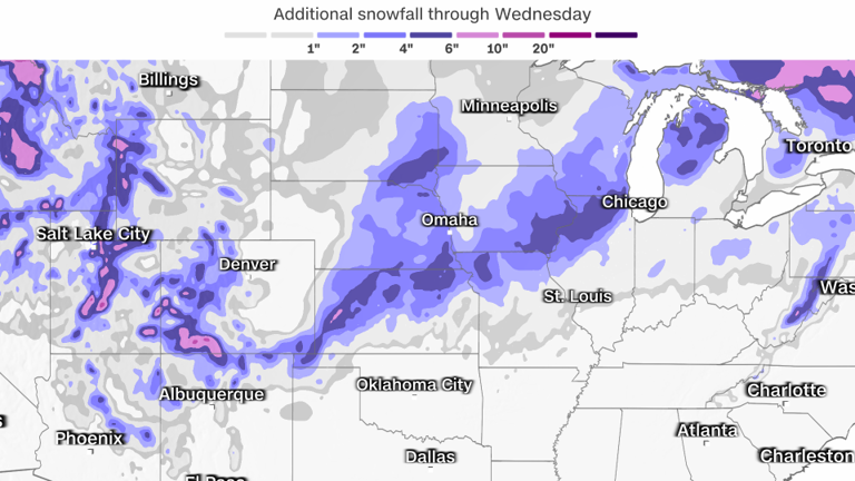
Although it will be a fast-moving system, traversing over 1,800 miles in 72 hours, it will still produce notable snowfall across more than a half a dozen states.
Widespread snowfall accumulations of at least 6 inches are expected from northern New Mexico to the Upper Peninsula of Michigan.
Heavy snow and strong winds will create blizzard conditions Sunday as the storm exits Arizona and heads to the Texas and Oklahoma panhandle region Sunday night. Blizzard warnings were already hoisted in Colorado and New Mexico early Sunday morning.
Poor visibility and difficult-to-near-impossible driving conditions will set in for the Southwest on Sunday, the central and southern Plains on Monday and the Midwest on Tuesday.
Strong winds will also bring wind chill values below zero degrees for some locations in the Plains.
Snow and cold temperatures will not be the only concerns as the storm surges northeast, intensifies and expands its reach to much of the eastern half of the US into the middle of the week.
Flooding, damaging winds and even tornadoes will also be concerns.
Along the Gulf Coast, warm, moist air will fuel the threat for severe storms, including a few strong tornadoes and damaging winds.


